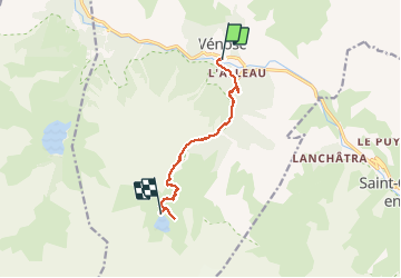
![](/images/other/stat-length.png)
![Tour Wandern Les Deux Alpes - 2020-09-01 Marche Venosc Refuge et lac de la Muzelle - Photo](https://media.geolcdn.com/t/1900/400/37e869b2-5bed-4bce-85a1-f553a21d8058.jpg&format=pjpeg&maxdim=2)
2020-09-01 Marche Venosc Refuge et lac de la Muzelle
holtzv
Benutzer GUIDE
![Länge](/images/other/stat-length.png)
![Maximale Höhe](https://static1.geolcdn.com/siteimages/upload/files/1508320355ic_sort_altitude_max_24dp.png)
![Positive Höhendifferenz](https://static1.geolcdn.com/siteimages/upload/files/1508320355ic_sort_den_pos_24dp.png)
![Km-Effort](/images/other/stat-length.png)
![Min. Höhe](https://static1.geolcdn.com/siteimages/upload/files/1508320355ic_sort_altitude_min_24dp.png)
![Negative Höhendifferenz](https://static1.geolcdn.com/siteimages/upload/files/1508320355ic_sort_den_neg_24dp.png)
![Boucle](https://static1.geolcdn.com/siteimages/upload/files/16400158638029165_repeat_loop_refresh_sync_direction_icon.png)
![Wandern](https://static1.geolcdn.com/sitytour/trail-icons/101.png)
4h08
Schwierigkeit : Medium
![Scannen Sie diesen QR-Code, um die Tour in der SityTrail-Anwendung zu öffnen](https://capi.geolives.com/qq0zvz2zws4bq2lad0pu/sitytour/trails/2535118/qr.png?size=200)
Kostenlosegpshiking-Anwendung
Über SityTrail
Tour Wandern von 8,3 km verfügbar auf Auvergne-Rhone-Alpen, Isère, Les Deux Alpes. Diese Tour wird von holtzv vorgeschlagen.
Beschreibung
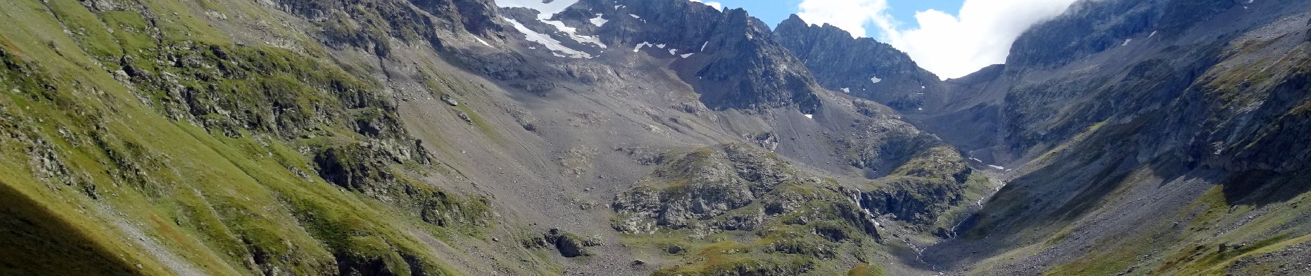
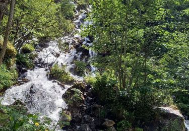
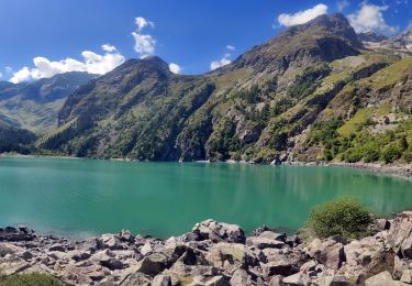
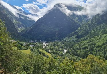
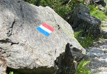
Au départ de Venosc, on emprunte le GR54C en passant par la cascade du ruisseau de Villeneuve, celle du ruisseau de la Pisse en finissant par les tourbières avant d’arriver au lac de la Muzelle. Petit crochet par la Roche Percée et les Cheminées de Fée avant de passer la nuitée au Refuge de la Muzelle devant le lac (alt 2100m).
Ort
Kommentare
Touren in der Umgebung
![Tour Wandern Les Deux Alpes - Lac Lauvitel depuis Venosc - Photo](https://media.geolcdn.com/t/375/260/c143dd5b-9bc9-4aa4-a71f-cc60077c341b.jpg&format=jpg&maxdim=2)
![Wandern Wandern](https://static1.geolcdn.com/sitytour/trail-icons/101.png)
Wandern
![](/images/other/stat-length.png)
![](https://static1.geolcdn.com/siteimages/upload/files/16400158638029165_repeat_loop_refresh_sync_direction_icon.png)
![Tour Wandern Les Deux Alpes - 2020-09-01 Marche Tour de l'Aiguille de Venosc (2 jours) - Photo](https://media.geolcdn.com/t/375/260/34a6bca9-af34-47ba-b9a3-4e85df680f5f.jpg&format=jpg&maxdim=2)
![Wandern Wandern](https://static1.geolcdn.com/sitytour/trail-icons/101.png)
Wandern
![](/images/other/stat-length.png)
![](https://static1.geolcdn.com/siteimages/upload/files/16400158638029165_repeat_loop_refresh_sync_direction_icon.png)
![Tour Wandern Les Deux Alpes - 2020-09-02 Marche Refuge Muzelle Lac Lauvitel Venosc - Photo](https://media.geolcdn.com/t/375/260/c75743e1-22bd-4dec-87c4-57455ba46347.jpg&format=jpg&maxdim=2)
![Wandern Wandern](https://static1.geolcdn.com/sitytour/trail-icons/101.png)
Wandern
![](/images/other/stat-length.png)
![](https://static1.geolcdn.com/siteimages/upload/files/16400158638029165_repeat_loop_refresh_sync_direction_icon.png)
![Tour Wandern Saint-Christophe-en-Oisans - 0isans - Vénéon - du gîte du Plan du lac au Pont des Granges - AR - Photo](https://media.geolcdn.com/t/375/260/ext.jpg?maxdim=2&url=https%3A%2F%2Fservices.sitytrail.com%2FGeolivesWS%2FDownloadMedia.ashx%3FTrailID%3D440124%26Media%3Dfix__20150626103336.jpg)
![Wandern Wandern](https://static1.geolcdn.com/sitytour/trail-icons/101.png)
Wandern
![](/images/other/stat-length.png)
![](https://static1.geolcdn.com/siteimages/upload/files/16400158638029165_repeat_loop_refresh_sync_direction_icon.png)
![Tour Wandern Les Deux Alpes - Oisans - Vénéon - Le Lauvitel - Photo](https://media.geolcdn.com/t/375/260/ext.jpg?maxdim=2&url=https%3A%2F%2Fservices.sitytrail.com%2FGeolivesWS%2FDownloadMedia.ashx%3FTrailID%3D437032%26Media%3Dfix__20150622133152.jpg)
![Wandern Wandern](https://static1.geolcdn.com/sitytour/trail-icons/101.png)
Wandern
![](/images/other/stat-length.png)
![](https://static1.geolcdn.com/siteimages/upload/files/16400158638029165_repeat_loop_refresh_sync_direction_icon.png)
![Tour Wandern Saint-Christophe-en-Oisans - Oisans - Vénéon - Vallon de Lanchâtra - Photo](https://media.geolcdn.com/t/375/260/ext.jpg?maxdim=2&url=https%3A%2F%2Fservices.sitytrail.com%2FGeolivesWS%2FDownloadMedia.ashx%3FTrailID%3D435411%26Media%3Dfix__20150618132240.jpg)
![Wandern Wandern](https://static1.geolcdn.com/sitytour/trail-icons/101.png)
Wandern
![](/images/other/stat-length.png)
![](https://static1.geolcdn.com/siteimages/upload/files/16400158638029165_repeat_loop_refresh_sync_direction_icon.png)
![Tour Wandern Les Deux Alpes - Ferraret village du Venosc - Photo](https://media.geolcdn.com/t/375/260/16333e30-f56d-457a-acb2-97a1c2e77d5f.jpg&format=jpg&maxdim=2)
![Wandern Wandern](https://static1.geolcdn.com/sitytour/trail-icons/101.png)
Wandern
![](/images/other/stat-length.png)
![](https://static1.geolcdn.com/siteimages/upload/files/16400158638029165_repeat_loop_refresh_sync_direction_icon.png)
![Tour Wandern Les Deux Alpes - Lac lauvitel e boucle descente par le GR trace réelle - Photo](https://media.geolcdn.com/t/375/260/d0c34587-c72a-43b6-9009-378bbac0bd3c.jpg&format=jpg&maxdim=2)
![Wandern Wandern](https://static1.geolcdn.com/sitytour/trail-icons/101.png)
Wandern
![](/images/other/stat-length.png)
![](https://static1.geolcdn.com/siteimages/upload/files/16400158638029165_repeat_loop_refresh_sync_direction_icon.png)
![Tour Wandern Les Deux Alpes - Venise le lauvitel - Photo](https://media.geolcdn.com/t/375/260/04546b3c-8a5a-43b8-a9f0-58cff4d320ee.jpg&format=jpg&maxdim=2)
![Wandern Wandern](https://static1.geolcdn.com/sitytour/trail-icons/101.png)
Wandern
![](/images/other/stat-length.png)
![](https://static1.geolcdn.com/siteimages/upload/files/16400158638029165_repeat_loop_refresh_sync_direction_icon.png)